Improve Accuracy, Efficiency, and Collaboration on Architecture, Engineering, Construction, and Facilities Management Projects with 3D Laser Scanning Solutions from Aspect Geospatial LLC
Say goodbye to tedious manual measurements and hello to unparalleled accuracy, efficiency, and collaboration. At Aspect Geospatial, we specialize in 3D laser scanning technology that quickly captures existing conditions with pinpoint accuracy, saving you valuable time and resources.
Our scanning solutions streamline the measurement process, delivering comprehensive data in a format that integrates with your workflow, in record time. Whether you're assessing a construction site, renovating a building, managing a facility, or planning interior design layouts, our scans provide an exact digital replica of the environment, eliminating guesswork and costly errors.
We also recognize the importance of communication and collaboration in every project. That's why our platform enables seamless stakeholder engagement and decision-making. With easy access to our cloud-based platform, clients, architects, engineers, and contractors can explore, analyze, and annotate the scanned data together in real-time, fostering transparency and ensuring alignment every step of the way.
With Aspect Geospatial, you're not just investing in a scanning service; you're investing in a transformative approach to project management. Join countless satisfied clients who have unlocked the power of accuracy, efficiency, and collaboration. Elevate your projects to new heights with our 3D Laser Scanning Solutions.
Aspect Geospatial LLC
Aspect Geospatial LLC is a local Fort Collins business with 20 years of technical geospatial experience. Our professionals capture accurate and affordable 3D building laser scan data for all your reality capture needs. We bring the project site to your desktop or mobile device in an immersive and interactive digital twin that will reduce site visits while also reducing costs.
3D Laser Scanning
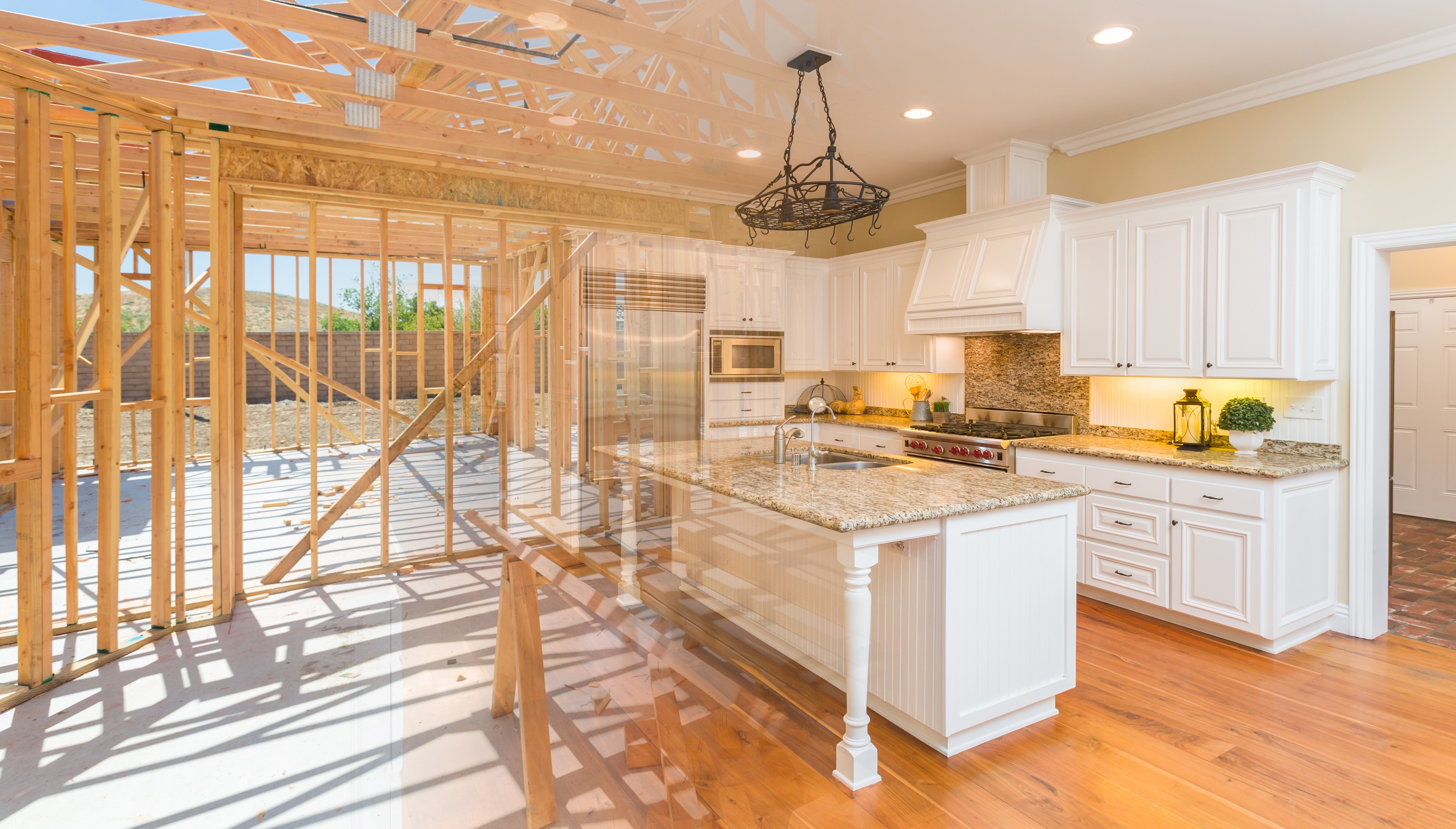
Laser scanning is a technology that captures the shape, dimensions, and surface characteristics of physical objects or environments by using laser light to create a point cloud of 3D data or digital twin. The captured point cloud can be imported into various design software to create 2D or 3D AutoCAD drawings or building information modeling (BIM) models in 3D.
Digital Twin
A digital twin is a digital representation of a physcial asset or environment allowing stakeholders to monitor the performance and lifecycle of a project. They are often captured in the project planning stage and span the entire asset's lifecycle from design and construction to operations and maintenance. Digital twins incorporate data traditionally kept in paper files, connecting teams, and providing a platform for collaboration throughout the entire lifecycle of a project.
Reality Capture
Reality capture technology is the replication of the physical world into a digital or virtual environment. It can be used to monitor the progress of a construction project or as a quality assurance comparison of the as-built to design models to reduce project risks. Reality capture is a rich documentation that provides unlimited access in a digital environment for stakeholders to re-visit project sites.
Architecture, Engineering, & Construction
Remodel and New Construction
Are you spending valuable time measuring project sites, then manually drafting existing conditions? How many times are you returning to the project site to verify measurements or site conditions? Contact us now to learn how Aspect Geospatial's services will reduce costs, save labor hours, and improve stakeholder collaboration for your projects.
• As-Built Documentation
• Scan-to-CAD and Scan-to-BIM
• Condition Assessments
• Progress Monitoring
• Milestone Tracking
• Closeout Documentation
• Specification / Warranty Documentation
• Collaborate with Stakeholders
Business Marketing
Google Business View
Engage and improve customer experience with an immersive tour of your business interior. Create a virtual showroom your customers can access by publishing to Google Street View and also by sharing on social media sites.
Facilities Management
Increase Efficiency
Reduce time to survey existing building conditions. Track and manage building maintenance tasks. Attach instruction manuals, asset specifications, warranty information, and repair videos to assets.
Hospitality
Vacation Rentals and Event Spaces
Vacation rental and hotels with 3D virtual tours increase bookings by 14% and have 300% greater engagement over 2D imagery. Take your home rental how-to instructions digital allowing clients to search features for their location.
Real Estate
Residential and Commercial
74% of agents using digial twins win more listings. 95% of people are more likely to inquire about properties with 3D virtual tours. 99% of sellers agree having a digital twin in thier listing would be a competitive edge.
• 3D Tours Compatible with Real Estate Apps
• 4K Print-ready Photographs
• Floor Plans
• Defurnish spaces
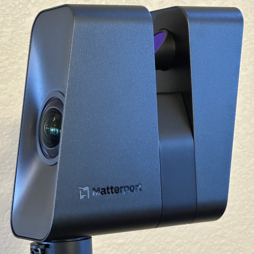
3D reality captured with Matterport's Pro3 LiDAR camera.
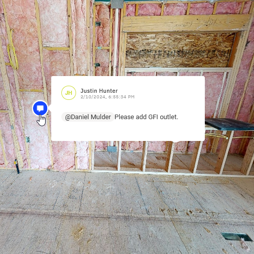
Collaborate with project stakeholders on the digital twin platform.
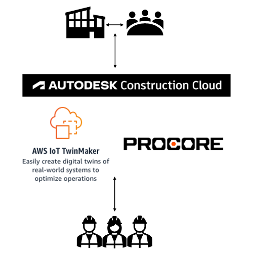
Integrate with Autodesk Construction Cloud, AWS IoT Twinmaker, or Procore.
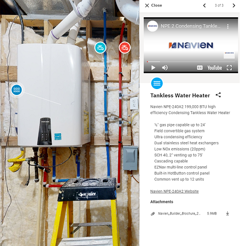
Upload digital media to tags such as videos, images, and documents.
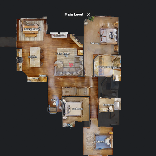
Label rooms and levels providing additional information to clients.
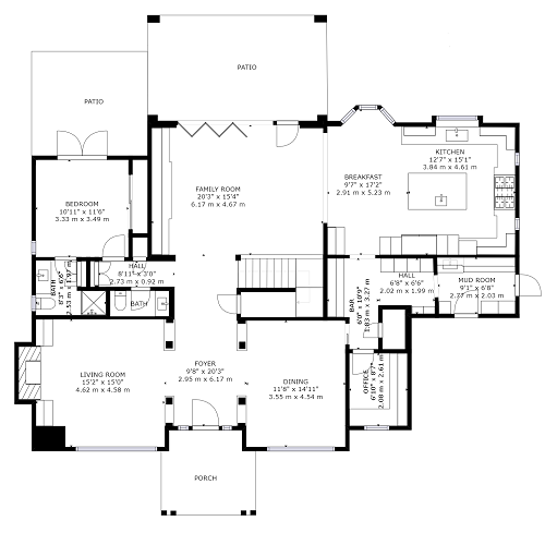
Schematic floor plan of the space can easily be converted to a CAD dwg file.
| Service | Description | Price |
|---|---|---|
| 3D Digital Twin | 3D laser scan of a space with a LiDAR camera. Cost is calculated by square footage. | $200+ |
| Add-on | Description | Price |
| Images | Indoor and outdoor print-ready 4k photographs. | $25+ |
| Floor Plan | 2D schematic floor plan of the structure. | $25 |
| 3D Pack | 3D .obj mesh file, colorized .xyz point cloud, reflected ceiling plan, and floor plan. | $65 |
| 3D Point Cloud | A vendor neutral .e57 file that can be imported into most design software. | $125 |
| ReCap Pro File | An Autodesk ReCap Pro .rcp file ready to import into Autodesk Revit and begin drawing. | $125 |
| CAD File | ISO 13567, the international computer-aided design (CAD) layer standard. | $125+ |
| BIM File | LOD 200 building information model (BIM) in .rvt and .dwg format. | $250+ |
| Video | A video walkthough of the virtual project site. | $125+ |
Contact Us
Aspect Geospatial LLC is located in Timnath, Colorado servicing Colorado and Wyoming. We use the Matterport Pro3 reality capture camera to create an accurate 3D laser scan of your site. Email us today to schedule your appointment or inquire about our services and pricing!